 MORE on WICHITA TRANSPORTATION
NOTE: Except as noted, these comments are the opinions, perceptions or recollections of the author. No guarantee of accuracy is made; however a reasonable effort has been made to realistically reflect the author's life-long familiarity and involvement with the community.
|
This section provides incidental information. It is not intended to be comprehensive, but to offer useful information. Most items are simply links to other sources.
|
For MORE information on Wichita-area transportation issues, see these additional topic sections below:
ROADWAYS
STREET SYSTEM:
Wichita has an above-average roadway system, with well-paved streets mostly on a neat, orderly rectangular grid, with major ("arterial") streets at one-mile intervals, and semi-arterial streets at half-mile intervals.
Streets are numbered from the downtown intersection of:
-
Douglas Avenue
(half-mile north of U.S.54 / Kellogg), and
-
Main Street
(2 blocks west of U.S.81 / Broadway).
Newer sections of the city, however, have degenerated to winding minor streets through residential neighborhoods -- deterring transient traffic, and arguably slowing most traffic. Arterials, however, remain straight on the rectangular grid.
HIGHWAYS:
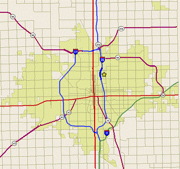
Wichita is connected to the rest of the state and nation by five highways -- Interstate, U.S. and State -- and by a turnpike (also an Interstate highway). Two highway bypasses also encircle most of the city; connected to the turnpike, they provide a complete circle around the fringes of the city.
Two old U.S. Highways, shown on the map as RED lines, run through the center of the city, and provide the core structure of Wichita's street system.
- U.S. 54 -- Kellogg Avenue in Wichita -- running east-west-- has long been the principal highway through the city, channelling Wichita life and development. Through most of Wichita, it is a 6-lane (or wider) divided, limited-access expressway, with interchanges at most mile-road arterial intersections. Adjacent corrollary roads shadow much of its route, though nowadays they are only sporadically connected to the highway -- changes in recent decades that have sharply altered East Wichita's commercial corridor.
...and...
- U.S. 81 -- Broadway Avenue in Wichita -- is the primary north-south arterial through the center of the city. However, Broadway is only a normal four-lane arterial street, with stoplights at major intersections. This was the original primary highway through the middle of city, and old motels along its route hint at what once was (those motels now form the core of Wichita's wretched "Skid Row," north and south of downtown).
Two newer Interstate Highways, shown on the map as BLUE lines, run through the city north and west, providing the main north-south expressway routes through the city.
- I-135 -- the Canal Route (as it's commonly known, for the drainage canal it straddles), is officially named Martin Luther King, Jr. Highway in Wichita (as a nod to the African-American neighborhood that its construction wrecked). The Canal Route is now the principal north-south expressway through the middle of the city, two miles east of downtown. A limited-access, 6-lane, divided highway, it is mostly elevated, with interchanges at (or near) most mile-road arterial intersections.
...and...
- I-235 -- the West Side Bypass (as it's commonly known), is a bypass expressway circling through the west side of the city, four miles east of downtown. (When built, this was the western edge of the city, as defined by "the Big Ditch," Wichita's massive flood-control canal, along the bypass's western edge.) A limited-access, 6-lane, divided highway, it is mostly elevated, with interchanges at (or near) only a few mile-road arterial intersections, owing largely to the high cost of bridging the adjacent Big Ditch, and the presence of the vast Wichita airport, just west of its southern half.
The Kansas Turnpike, shown on the map as a GREEN diagonal line across Southeast Wichita, is also officially Interstate Highway I-35, connecting Dallas and Oklahoma City to Kansas City, through Wichita. The highway is a freeway runing straight north, until reaching the Kansas line. It continues straight north until reaching the south edge of Wichita, then turns northeast, along the city's southeast edge, continuing on to El Dorado, then Emporia (where I-35 diverts to a freeway for Kansas City) and then Topeka. The Turnpike finishes by running east from Topeka through Lawrence, into Kansas City. The Turnpike is a very-limited-access expressway, with four toll booth interchanges along its route through Wichita, and near the suburbs of Haysville (south) and Andover (east):
-
South Wichita interchange connects to I-135 (the Canal Route) and I-235 (the West Side Bypass), which, together, also immediately connect to 47th Street South near its intersection with Broadway/U.S.81.
-
Southeast Wichita interchange, near the Boeing/Spirit factory complex, connects the Turnpike to K-15 near MacArthur and Oliver.
-
East Wichita interchange connects the Turpike to Kellogg/U.S.54 near Webb Road.
-
Northeast Wichita interchange (horribly located) very awkwardly connects the Turnpike to K-96 (Northeast Bypass) near its Kellogg/U.S.54 interchange, with a connecting road to Central near Greenwich Road.
Three Kansas State Highways, shown on the map as PURPLE lines, connect the city to suburban and rural areas and neighboring towns.
- K-96, a divided, 4-lane, limited-access highway, which originally connected Wichita from North Broadway / U.S. 81 to points northwest (mainly Hutchinson, Kansas). It has been extended east, in recent years, to serve as the "Northeast Circumferential Bypass" -- a divided 4-lane limited-access bypass around the northeast corner of the city, connecting the north end of the city (and highways I-135, I-235 and U.S.81) to the Kansas Turnpike and U.S. 54 Highway (Kellogg) at the eastern edge of the city.
...and...
- K-15 (Southeast Boulevard) -- mostly a limited-access, divided, 4-lane boulevard (with stoplights at major intersections) -- connects Wichita from Kellogg, just east of downtown (at Washington Street) diagonally south-southeast towards the Boeing/Spirit factory complex, and to suburban Derby, and, in an adjacent county, Winfield and Arkansas City.
...and...
- K-42 (Southwest Boulevard) -- mostly a limited-access, divided, 4-lane boulevard (with stoplights at major intersections) -- connecting Wichita from Kellogg, two miles west of downtown (at Edwards Street) diagonally southwest towards the Cessna and CNH factory complexes southwest of the city, and to rural Clearwater and Viola, and points southwest.
Three local boulevards, shown on the map as GRAY curving or diagonal lines, also defy the city's neat grid structure:
Boulevards:
- Highway K-15 (see above), in Wichita, is also marked as
"Southeast Boulevard", and is a divided four-lane, tree-lined. limited-access boulevard between Washington and Pawnee.
- Highway K-42 (see above), in Wichita, is also marked as
"Southwest Boulevard", and is a divided four-lane, limited-access expressway between Kellogg and Tyler Road.
- Zoo Boulevard, a divided, 4-lane, limited-access boulevard, helps connect inner-city Wichita to suburban northwest Wichita, departing Central Ave. at St. Paul Ave., heading diagonally straight northwest though 13th and West Streets, through an interchange with the I-235 and over the Big Ditch. There, it forks -- one fork as "Windmill Road" heading southwest to 13th and Ridge Road, while Zoo Boulevard, proper, continuing northwest, passing by the Sedgwick County Zoo and terminating into 21st St. North. This route is an extremely busy connection to the I-235 bypass and Northwest Wichita.
...and...
- McClean Boulevard, an undivided, 4-lane, limited-access boulevard, winds along the west bank of the Arkansas River from 31st Street South, to the river fork just northwest of downtown, and follows the Big Arkansas fork around until crossing over it just south of the Twin Lakes shopping center at 21st and Amidon.
 This route is somewhat important as a commuter route, particularly connecting northwest and southwest Wichita to downtown, but is also very important and popular as the "scenic" route across town, or simply as a recreational drive, just for the river view. In an urban, flat-land city that has desperately little scenery, McClean's long, liesurely riverbank tour is a precious blessing to many.
Efforts began in the 1970s and 1980s to reroute part of McClean away from the river -- near the fork, just west of downtown -- to accomodate various development ideas of city officials and land-developers. The move created extreme agitation, and even anger, amongst many in the city, and some neighborhood government councils and civic organizations argued strongly against it. In the end, a few hundred yards of McClean were moved away from the river just enough to allow for the construction of the Exploration Place science museum, but the rest of its route remains along the riverbank.
The street is usually fully functional, and provides an expedient reliever route for the nearby (and often overburdened) Seneca Street arterial, one of Wichita's busiest streets, which parallels McClean a half mile to the west. However, fair-weather complications for McClean include its occasional half-mile shutdown, near downtown, for baseball games at the adjacent Lawrence-Dumont Stadium, and the shutdown of several sections near downtown during Wichita's annual late-spring / early-summer River Festival, or for other events.
...and...
- George Washington Boulevard (once known as "GWB" -- and not to be confused with the inner-city, north-south, arterial
"Washington Street"), is an elegant, tree-lined, partially-divided, 4-lane, limited-access boulevard, originally meant to connect downtown Wichita to the City's previous Municipal Airport (now McConnell Air Force Base), at the southeast edge of the city.
The Boulevard's northern end has long since been truncated, and it now starts at the intersection of Grove and Lincoln, just east of the I-135 (Canal Route) Lincoln Street interchange -- site of the now largely defunct Boulevard Plaza shopping district. It heads southeast through Harry, Hillside, Mount Vernon, Pawnee and Oliver, runs along the western edge of McConnell Air Force Base, and terminates at the old airport terminal buildling (now the Kansas Aviation Museum).
Wichita's municipal airport moved to southwest Wichita in the 1950s (to make way for McConnell Air Force Base), and southeast Wichita is fading. Conseqently, the boulevard is now under-utilized. But GWB still serves as a conduit for some commuters working at the air base or aircraft factories southeast of town, and provides one of the most delightful routes through Wichita, and remains treasured by Southeast Wichitans.
ROADWAY CONDITIONS:
Though Wichitans (like people everywhere) constantly gripe about the conditions of their streets, they actually have some of the highest-quality streets of any city in America, on an average basis -- though the quality has generally been declining (especially on residential and semi-arterial streets), except in newly developed and upscale areas.
Paving & Repaving:
Wichita has a sizeable cache of old brick-paved streets, and until recent decades, concrete was used to pave many of Wichita's streets, with excellent results and longevity. Some concrete is laid in new areas, and new ornamental brickwork decorates the streets in Downtown.
But the growing influence of asphalt-paving companies in state and local politics, and the deteriorating commitment of local voters and political leaders to long-term thinking and sober investments in infrastructure, has resulted in an apparent increase in the frequency with which short-life asphalt is used as the pavement of choice -- noticeably degrading Wichita streets over time.
Troubled Bridges over Waters, and more...
Even more significant, and dangerous, is the civic "leaders" unwillingness to invest in other, high-cost, high-value, long-payback infrastructure -- including the crucial replacement of aging bridges and overpasses -- some of which trace their origins to the 1930s public-employment projects of the Great Depression, and others that harken to the federally-funded public works of the 1950s and 1960s. Wichita's increasingly conservative and libertarian politics have sharply undermined any public investment in infrastructure, and the only major bridge replacement in recent years was the South Broadway railroad overpass, done only after the original bridge began crumbling, and had to be partially shut down.
Streetlights Dimming...
Wichita streets are generally well-lit (reportedly about 23,000 streetlights for about 5,000 intersections and 6,000 miles of roads, not counting alleys) but -- like Wichita's bridges and overpasses -- the lights are very poorly maintained. It is common for whole city blocks of arterial streets to be in the dark -- with blackouts that often stretch for a half-mile or more, lasting for months, despite public complaints and citizens' notification of the both the city government and the responsibile electric utility.
A "franchise agreement" contract with Westar Energy (giving it exclusive electric utility rights in Wichita) require the utility to maintain the streetlights, but they have stubbornly failed to do so, despite repeated demands by city authorities.
However, the City Council has not brought the city's full legal powers to bear on Westar to force compliance. Some City Council members, over the years, have accepted campaign donations from Westar and its executives, and -- in one case -- a Westar official's spouse was a member of the City Council.
Additionally -- starting in the downtown area, and gradually radiating outward -- the city has begun switching to extremely poor lighting of streets for aesthetic reasons, and to improve the visibility of stars in the sky by reducing "light pollution." Extreme caution is advised when driving in these areas after dark. Any visibility problems (rain, a scratched or dirty windshield, foggy headlights, bad eyesight) are compounded dangerously by the new streetlights, and can make pedestrians essentially invisible -- even in pedestrian-rich Downtown.
UPDATE, Nov 2019:
Westar Energy has been merged with Kansas Power & Light (KP&L) to form a much larger utility: Evergy. With the increased size of the utility, it poses an even greater challenge to city officials, should they attempt to sue the company to get the neglected lights attended to. Prospects for an improvement of the situation are dim.
On a birighter note, however, the City has apparently partially reversed its practices of installing minimal lighting in many high-traffic areas. Most of the areas afflicted by the previous sparsely distributed, hooded, ineffective new lights have again been relighted -- this time with newer, more numerous and more effective lights. However, some problems remain -- particularly at intersections where the ineffective hooded lights were integrated with the intersection signal lights, on the same poles; in some of these interesctions, all street-illumination lights are out.
ACCIDENTS & HAZARDS:
Accidents on Wichita's streets are largely concentrated along Kellogg/U.S.Hwy.54 -- though most major intersections in the city are ripe for accidents. A city report, published in part by KAKE-TV News, shows the 50 most hazardous intersections in Wichita, ranked by the number of accidents per year:
Wichita's generally foul weather (hot, cold, windy &/or rainy) creates numerous challenges for drivers. Precipitation often slickens the streets, though not as severely as in most northern and southeastern states. In particular, winter precipitation commonly results in icy roadways, resulting in numerous accidents, and even, occasionally, forcing the closeure of some key bridges, and some highway ramps and overpasses. The endless and often severe Kansas wind can also create difficulties for drivers -- especially those operating tall vehicles. Wichita's generally moderate traffic congestion, though, reduces the impact of these hazards somewhat.
ROADWAY NEWS & CONTROVERSY:
- DOUGLAS AVE.:
- HARRY STREET:
WATERWAYS
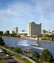
Wichita's only true waterways are the Arkansas River, and its main tributaries -- the Big and Little Arkansas Rivers -- which join to form the main river just west of Downtown. The river is not navigable for long distances, except by very-shallow-draft boats canoes and kayaks.
(This problem is partially due to damming and drainage of the Arkansas River waters upstream, particularly in Colorado, but also in Kansas, for irrigation and urban use. At some times, much of the Arkansas River, in Western Kansas, is completely empty, and the riverbed dry. In those times, Wichita's wet Arkansas River depends wholly upon tributaries in Kansas and dams in Wichita)
Dams at the confluence of the rivers, just northwest of Downtown, and at Lincoln Street, just south of Downtown, help maintain water depth, but also create hazards to navigation. Additionally, the Lincoln Street Dam is adjustable, and is frequently lowered.
The vagaries of drought and flood tend to create unreliable boating conditions all along the river. Sandbars and snags are common, and -- especially on the main river -- currents can be swift and dangerous, especially during periods of intense rain, and long thereafter.
Fishing on the river is popular with some, and particularly common on, and around, the Lincoln Street Bridge and Dam — though state and local health officials occasionally issue warnings that the river is too polluted for fishing, swimming or boating.
- Arkansas River
Local Creeks and Streams
Wichita's various other creeks and streams (including the wildy variable channel of the Big Ditch), are generally unsafe for boating, owing to narrow, shallow channels — often with sandbars, snags, low bridges, culverts and other obstacles, and unpredictable depths and currents. They largely run through private property, and are considered a part of the adjacent landowner's property, and hence out-of-bounds (also true of much of the Little Arkansas River).
Boating on Local Lakes
Several small sand-pit lakes — some nearly a square mile in size, and suitable for boating — dot the Wichita landscape, especially south and west. They are mostly leftovers from ancient channel changes of the Arkansas River and its tributaries.
Though nearly all are private property, the lake at O.J. Watson Park in South-Central Wichita -- immediately southwest of the Arkansas River, on McClean Boulevard, south of Pawnee -- is in a public park. During warm months, the Park offers inexpensive rental of canoes and paddle-boats for human-powered puttering around the horseshoe lake in the park, but does not allow private boats. (Pony rides for children, and miniature train rides through the park, are also offered affordably).
Two other lakes in Sedgwick County, and two in neighboring Butler County to the east, offer fuller range of boating opportunities:
- Tree-lined, meandering Lake Afton is in southwest Sedgwick County.
- Much larger Cheney Reservoir ("Lake Cheney") in the northwest corner of the county, spreading west into adjacent counties. At Cheney, motorboating and sailboating are common, as is boat fishing.
-
Santa Fe Lake near Augusta, 20 minutes to the east, is popular with sailboats.
-
El Dorado Lake, 45 minutes to the east, is a massive, recent reservoir, dotted with old tree lines in the water, and occasional bald eagles.
Boating across Kansas
 Several boating lakes (particularly large reservoirs) are available throughout Kansas, including Fall River and Toronto, a couple of hours' drive east. Others exist as well. Water condition is occasionally unhealthy, but usually safe.
Kansas rivers are generally unreliable and/or unsafe for boating, and sometimes too polluted for recreation.
Polluted Kansas Waters
Kansas rivers are frequently, almost constantly, polluted by "agricultural runoff" -- rain and drainage runoff from fields polluted by pesticides, herbicides and fertilizer, and runoff from feedlots, pastures and corrals polluted by animal waste.
Toxic algae blooms, resulting from the pollution, are another major source of water contamination. (Of particular note are BGA -- blue-green algae -- blooms. For more on that problem, see:
"Blue-Green Algae (BGA)" site of the Kansas Department of Health and Environment (KDHE).
In the late 1970s, the problem was so severe that the federal EPA (Environmental Protection Agency) cited Kansas as the state having the most polluted rivers and streams in the nation.
Aggressive government regulatory activity -- fought by Kansas' powerful agricultural lobby -- has ameliorated some of that problem, but it remains a constant issue for Kansas waterways.
From time to time, state and local health officials issue warnings that certain rivers or lakes are too polluted for fishing, swimming or boating.
Kansas Waterways: Additional info:
AVIATION
Wichita is one of the primary industrial centers of the world aviation industry, producing more aircraft than any other city in history. Not surprisingly, then, Wichita is surrounded by an exceptional wealth of airports, for an isolated city of only 400,000.
Atlas of Kansas Aviation
Multiple Wichita-Area Airports:
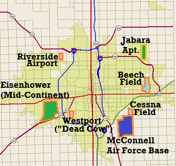
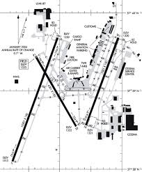
The map below shows the principal airports within or adjacent to the Wichita city limits.
- Dark Green airports are Wichita's municipal airports:
Eisenhower / Mid-Continent to the southwest is the city's main airport and its airline and air-cargo terminal, major general aviation facilities, and home to planemakers Textron/Cessna and Bombardier/Learjet).
- Jabara Airport, to the northeast, is the city's "reliever" general aviation airport).
- Pink airports are popular private airports:
- Westport (better known as "Dead Cow") to the southwest, and
- Riverside (now closed) to the northwest.
- Light blue airports are private airports of planemaker Textron Aviation:
- Beech Field, to northeast, and
- Cessna Field, to the southeast.
- Dark blue airport is
- McConnell Air Force Base -- a restricted military field, shared with the Spirit Aerosystems factory.
The Wichita area includes these airports with long or medium-length runways, certified instrument approaches and extensive facilities:
 WICHITA AIRPORTS:
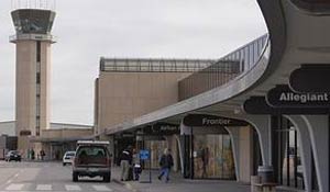
- Eisenhower Airport — previously Mid-Continent Airport — the city's main municipal airport, in southwest Wichita, with 12,000-foot runways accommodating all planes but the giant Airbus A380.
Airlines:
Eisenhower Airport provides extensive airline servce (including jetliners from most major U.S. airlines, on routes to hubs and major destinations across the nation), and also provides support for air cargo operations.
General Aviation & Plane-Makers:
The airport also supports general aviation (home to prop and jet flying services with training, charter, air-taxi and air-ambulance services), and local aircraft manufacturers (Textron: Cessna / Beech / Hawker; and Bombardier / Learjet) based on the airport's periphery. FlightSafety International, the American Bonanza Society and AOPA have major facilities here.
Facilities:
Airport facilities include car rentals, restaurants, and a large hotel with convention facilities. Eisenhower is an international "port of entry," with U.S. Customs agents on call.
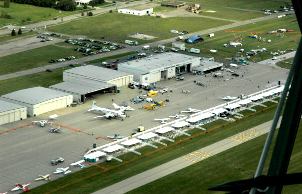
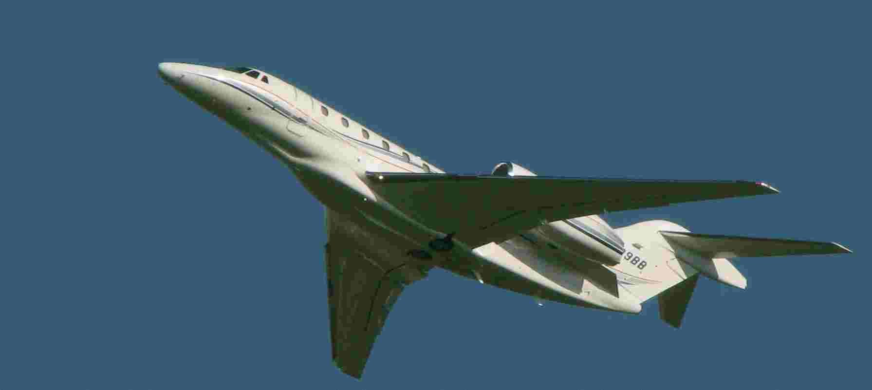
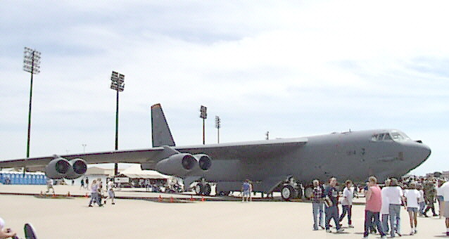
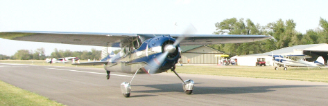
- Jabara Airport - the city's official general aviation "reliever" airport (shown at right, during an airshow) in Far-Northeast Wichita, an un-towered airport accommodating most business jets (and a Boeing 747 has even successfully landed there). Cool to light plane owners -- private contractor operating the field clearly prefers high-dollar bizjet customers. Also home to Wichita's grandly-named "NCAT - National Center for Aviation Training" -- the local public technical college's training facility for aircraft mechanics.
- Beech Field - in Far East Wichita, a large, but restricted, private airport, with a control tower, that is home to the original Beech Aircraft factory, now part of Textron (Cessna / Beech / Hawker). Accomodates large business jets.
- McConnell Air Force Base - a major Air Force Base, on the city's southeast edge, home to the largest segment of the nation's aerial tanker fleet. Shared with adjoining former Boeing factory facilities now operated by Boeing subcontractor Spirit Aerosystems. Access is restricted. Kansas Aviation Museum is immediately adjacent, on east side of base.
NEIGHBORING TOWNS:
- Augusta Municipal Airport - 15 minutes east of Wichita, a popular, un-towered, general aviation airport that still welcomes small planes and middle-class aviators, but can also accomodate small jets. Local operators provide airplane and helicopter training and rentals.
- Stearman Field (Benton Airport) - 20 minutes northeast of Wichita, a popular and growing un-towered general aviation airport, with a popular restaurant — though becoming "gentrified," with adjacent upper-class homes for aviators and their planes. Can accomodate small jets.
Participate - Let your voice be heard!
|
|